
Solving the challenge of in-tunnel GNSS

Modern traffic management and control systems require accurate and reliable location services. However, global navigation satellite system (GNSS) signals, which are a cornerstone of modern navigation, are rendered useless in tunnels and other subterranean environments. This creates a critical ‘black hole’ in navigation and location tracking, impacting everything from traffic flow monitoring to emergency response.
An effective solution is to regenerate real-time GNSS signals within tunnels to ensure continuous, accurate positioning. Enabling standard GNSS receivers to function seamlessly in these environments, this technology enhances safety, improves traffic management, and provides crucial location data for emergency services.
The ‘black hole’ of underground navigation
While consumer vehicle GNSS navigation systems typically provide an accuracy of around 2–4 m in open-sky conditions, the technology falls short in areas without a direct satellite view, such as in underground roads or mining tunnels. In order to understand why, it's essential to grasp how a GNSS receiver calculates its position. The process relies on decoding four critical types of data from satellites:
- Almanac: Information about the satellite’s orbit and status.
- Ephemeris: The satellite’s precise position.
- Pseudo-random code: Used to calculate the signal’s travel time from the satellite.
- UTC (Universal Time Code): For accurate timing.
Clear line of sight to a minimum of four satellites is required to calculate a precise 3D position (latitude, longitude and altitude). When a vehicle enters a tunnel, this line of sight is instantly lost, and traditional GNSS navigation becomes ineffective. This results in a critical loss of data that can impact operational efficiency and, more importantly, safety. The vehicle’s last known position is the only data available, leaving a significant gap in real-time tracking.
A common but fundamentally flawed approach is to use an external antenna to capture a signal from outside a tunnel and simply rebroadcast it inside. This method is ineffective as a vehicle’s GNSS receiver will only calculate one position throughout the entire length of the tunnel: the location of the external antenna on the surface. This remains true even if multiple repeaters are used. Furthermore, this method is fraught with significant logistical and cost challenges, often requiring boreholes to be drilled to run cables to each repeater. Not only does the resulting inaccurate location data impact potential navigation applications, but the calculated altitude will also be entirely incorrect, posing a major issue in multi-level tunnels.
GNSS signal regeneration: an emerging solution
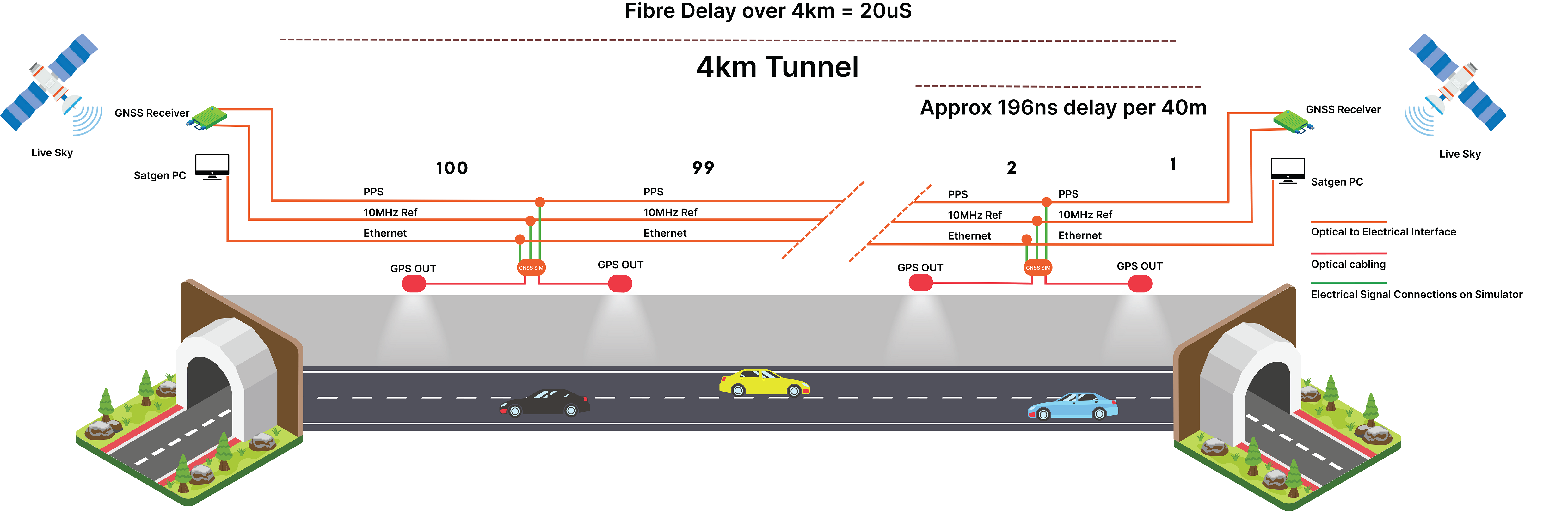
An effective solution to this problem is to regenerate modified satellite signals that are specific to the vehicle’s location within the tunnel. This is achieved by installing a series of radiating antennas in the tunnel ceiling. The signal from each of these antennas is relative to its precise position, including its longitude, latitude and altitude.
This ensures that as a vehicle travels through a tunnel, its receiver calculates its position relative to the nearest radiating antenna. To the vehicle traveling through the tunnel, its tracking unit will ‘see’ the same almanac and ephemeris data as if it were under an open sky. As the vehicle passes from the signal range of one antenna to the next, its position is seamlessly updated, providing accurate, real-time location tracking. The positional accuracy achieved is determined by the spacing of these antennas. In general, an AVL or telematics system will report between 10 seconds and 30 seconds; this knowledge in conjunction with the tunnel’s travel speed can be used to calculate appropriate antenna spacing. In an emergency, a vehicle’s stationary position will be precisely pinpointed to the location of the nearest antenna.
The technical components of GNSS signal regeneration
- Precision Time Protocol (PTP): A highly accurate PTP server with an external GNSS antenna that has an unobstructed view of live signals is needed to feed current and synchronised timing data throughout the system. This server’s time clock must be accurate to within a few nanoseconds of UTC for a seamless transition of live to simulated signals. This nanosecond-level accuracy is critical for avoiding timing glitches that could disrupt navigation systems. The PTP server acts as the master clock, ensuring that all signals broadcast in the tunnel are perfectly synchronised, a non-negotiable requirement for accurate positioning.
- GNSS simulation software: The PTP server feeds this satellite data to a computer running dedicated simulation software. The software is meticulously configured for the surveyed location within the tunnel, taking into account the precise location and elevation of each radiating antenna. This software is the brain of the operation; it calculates the precise signals that need to be generated at each antenna point. Each tunnel environment’s unique bends, slopes, and number of radiating antennas all need to be accounted for to ensure a consistent and reliable signal across the entire length of the tunnel.
- Dedicated RF signal generators: The software outputs specific parameters to dedicated RF signal generators. These generators use the settings and the precise timing signals from the PTP server to generate the satellite radio frequency (RF) signals for each radiating antenna. The RF fields from these generators can be precisely tuned to match the specific tunnel environment, preventing signal leakage and ensuring safety. These generators are the physical manifestation of the software’s commands, broadcasting the simulated signals that are interpreted by standard GNSS receivers.
Benefits and use cases of GNSS signal regeneration
Road tunnels
The absence of GNSS in road tunnels poses a direct threat to public safety and traffic efficiency. Signal regeneration provides a comprehensive solution with several key benefits. It offers a way to enhance traffic management by providing accurate, real-time location data as well as insights for traffic flow monitoring, which assists in managing traffic congestion and improving overall operational efficiency. This information enables intelligent traffic systems to make data-driven decisions about lane closures, variable speed limits and incident management. Furthermore, signal regeneration significantly improves emergency response times. In critical situations, accurate and precise accident location data allows emergency services to navigate to the exact site of emergency in tunnels and other inaccessible subterranean areas, which can save lives by reducing response times. This technology is also universally compatible, providing true GNSS signals, unlike systems that rely on proprietary Bluetooth or Wi-Fi beacons that only work with modern devices and smartphones. This ensures true compatibility with all standard GNSS-enabled devices — including those found in transport fleets, commercial vehicles and emergency services — without requiring any new hardware.
Rail tunnels
For rail networks, the consequences of a loss of location data can be catastrophic. The high precision and reliability of GNSS signal regeneration make it an ideal solution for modern rail operations. Accurate GNSS signals enable continuous tracking of trains, locomotives and maintenance vehicles, which is crucial for efficient scheduling and management. Real-time location data is fed into control systems, allowing for granular control over train movements and congestion prevention. This ability to provide a precise location for every vehicle in a tunnel at all times can also be used to prevent collisions and ensure the safety of personnel working on the tracks, providing an additional safety net beyond traditional signalling systems. Seamless handover is also essential for rail signalling systems to prevent any timing glitches that could lead to signal failures or communication breakdowns.
Mining tunnels
Mining operations are complex, dangerous, and often take place in a network of underground tunnels where traditional navigation is impossible. GNSS signal regeneration provides a vital layer of safety and efficiency. Continuous GNSS signals are essential for the safe and efficient operation of autonomous vehicles and robotic systems used in modern mining. These systems rely on precise positioning to navigate, transport materials and avoid obstacles, and a loss of signal could bring operations to a halt or, worse, lead to a safety incident. The ability to precisely locate personnel and heavy machinery in this complex environment significantly enhances safety and allows for rapid response in case of an incident, where search and rescue teams can pinpoint a location with a high degree of accuracy. Real-time location data also allows for the optimised routing of vehicles and resources, improving productivity and operational efficiency by helping to manage the flow of equipment and materials, thereby reducing bottlenecks and downtime.
GNSS signal regeneration offers a comprehensive solution for road authorities and traffic management systems, as well as rail and mining operators that require reliable location services in challenging environments. Systems that embody these principles already exist; NoSky SatNav from Step Global is designed to provide GNSS signals in areas where seamless navigation is mission critical. By regenerating real-time GNSS signals, it resolves the critical problem of in-tunnel navigation, ensuring continuous tracking for operational efficiency and, most importantly, enhancing public safety.
Beating the jammers: Australian tech gives warfighters precision in GPS blackouts
Advanced Navigation's inertial-centric intelligence has succeeded in achieving navigation in...
Melbourne Metro Tunnel officially opens, featuring CBTC
The project is understood to feature Australia's first communications-based train control...
Ericsson improves wireless WAN for Sunswift Racing
Sunswift Racing is using technology from Ericsson Enterprise Wireless Solutions to provide...
")

