
Positioning system for open-cut mine
Locata Corporation’s integration partner, Leica Geosystems Mining, has released its Locata-powered positioning systems.
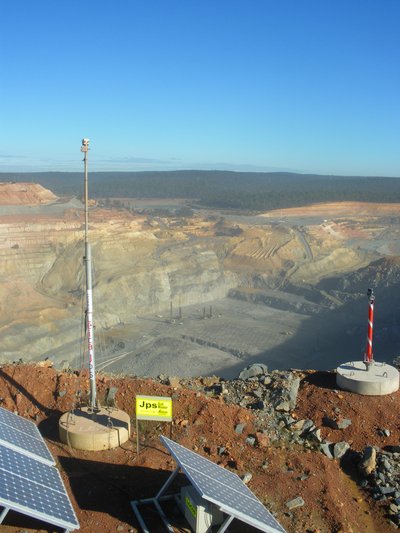
The Leica Jps (Jigsaw Positioning System) integrates global satellite navigation signals like GPS, and the company’s ground-based GPS-like networks.
The positioning system is providing positioning accuracy, availability and reliability to an ‘industrial-scale’ installation at Newmont’s Boddington Gold Mine.
The non-stop positioning benefits machine automation in mining because Locata fills in gaps in GPS signal availability experienced in an open-cut mine.
The system is suitable for demanding machine guidance applications because it uses all available signals, be they satellite based or Locata, without interruption.
Newmont Boddington Gold mine reported that the drill rig up-time and efficiency have “skyrocketed to unprecedented levels” after the Jps system was commissioned.
“Since deploying the Locata-powered Jps at Newmont Boddington Gold, there has been an increase in operational machine guidance availability of almost 23% - from 75 up to 98%,” stated Dr Brendon Lilly, product manager, Leica Geosystems Mining.
“Newmont Boddington Gold is so happy with the results that they have turned off their GPS-only solutions altogether, and now rely solely and successfully on Jps alone. They have already installed Jps on 11 drills and intend to equip their entire high-precision fleet.”
“The unprecedented production levels and machine control uptime that result directly from using the Locata-powered Jps very quickly justifies the purchase of the system,” said Stefana Vella, global marketing manager, Leica Geosystems Mining. “Furthermore, it aids the justification of expenditure on the high-precision machine guidance systems themselves, for, when operated with the Jps, the ROI increases exponentially.”
Many mines around the world use machine guidance systems for drills, shovels, excavators, dozers, graders and more to execute the site plan work in real time. This tight automation dramatically improves efficiency and productivity. At the core of these machine guidance systems are GPS-style receivers that provide vital positioning information, using the satellite signals to calculate a 3D position.
Unfortunately, in most open-pit environments satellite signals become obstructed, which slows or temporarily halts production. As pits become deeper the problems become worse, drastically reducing the number of satellites the receiver can ‘see’ to achieve GPS-style positioning.
In the past, mines and other machine automation users had no choice other than to resort to much less efficient alternatives, such as manual surveying. Reduced satellite visibility therefore negated the considerable investment and operational efficiencies gained from modern machine guidance systems. Something had to be done, and the key to virtually eliminate these issues is the ‘GPS-backup or replacement’ capability.
Locata has invented a device called a LocataLite - it’s a ground-based transmitter that generates a GPS-like signal. Transmitters deployed around the pit rim can ensure almost 100% positioning coverage. The signals ‘fill in’ the GPS holes with a signal that is processed by the positioning system in exactly the same way that GPS signals are.
By backing up their GPS-based systems, mines have an always-on positioning network that works if satellite signals are unavailable in the pit due to physical or man-made obstructions. The transmitter can be permanently positioned on site or moved at will, ensuring a mine’s network can be set up where and when needed.

“We all rely on electricity from public sources, but in areas where outages occur companies invest in backup generators,” said Nunzio Gambale, CEO and co-founder of Locata. “It’s exactly the same scenario for mining companies, where they are dependent on GPS. Locata gives you a GPS backup ‘generator’. Before Locata became available, mines simply had to suffer through a slowdown when GPS-based systems became flaky.”
John Carr, senior technical specialist at Newmont Boddington Gold Mine, said, “Open-cut mines, just like everyone else that depends heavily on satellite navigation, are already hitting the wall at the outer limits of GPS technology. With Locata, we’ve virtually eliminated everyday GNSS signal challenges and now we also have our own backup in place in case of a more significant or longer-term failure.”
Beating the jammers: Australian tech gives warfighters precision in GPS blackouts
Advanced Navigation's inertial-centric intelligence has succeeded in achieving navigation in...
Melbourne Metro Tunnel officially opens, featuring CBTC
The project is understood to feature Australia's first communications-based train control...
Solving the challenge of in-tunnel GNSS
GNSS signals are rendered useless in tunnels and other subterranean environments; an effective...


")