The building behind the address
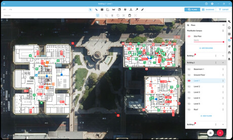
Outdoor mapping gets first responders to the address. Current indoor plans can show them what lies beyond the entrance.
Crews can navigate to a precise point outside a building relatively easily. The tougher challenge begins at the door: what’s the layout like inside, and can they trust whatever plans they have?
During the December 2014 Lindt Cafe siege, police sought information about the cafe’s layout and access. The NSW Coroners Court findings record that the building manager provided security and access information at about 10.30 am. Around 10.50 am, police asked a City of Sydney manager for the cafe’s floor plan. This sequence illustrates how information about a building can be held by different people.
For Locatrix co-founder John Hummelstad, it raised a broader preparedness question: if building information already exists, how can it reach responders when they need it?
“Critical building information already existed — but it was locked away, static, and hard to access when it mattered most,” Hummelstad said. “The opportunity was to make that information digital, current and put it directly in the hands of first responders.”
Get plans into the systems crews use
Responders already use mapping and information systems in their vehicles and on tablets. Indoor plans are most useful when crews can access them through those existing systems, alongside the location and incident information they already rely on.
Locatrix’s Emergency Services Platform (ESP) shares indoor building information with authorised emergency service agencies for emergency response. The base floor plan information is provided to responders at no cost. Locatrix says responders across three states already have access, and it is in discussions with fire services in every state.
Scott Jackson, Locatrix’s Chief Executive Officer, says responder feedback points to a practical benefit: crews can begin to orient themselves and consider routes before they enter an unfamiliar site.
“When crews arrive, they need to understand the building as well as the address. A plan in the systems they already use gives them a starting point: the layout, possible routes and details that may matter to the job.”
Alan Clarke, Assistant Commissioner APM Rtd, NSW Police, also sees the potential value for responding agencies. He said, “Locatrix have gone to considerable efforts to provide emergency services with indoor maps. This information will prove to be critical over time and will greatly enhance the situational awareness of responding agencies.”
Locatrix reports that its team has directly mapped 7791 buildings, and counting. Working closely with other safety experts, the Queensland-based team has extended its reach substantially through more than 400 service providers and seven channel partners. Together, the combined inventory includes 87,879 buildings and more than 144,000 active floor plans — and almost half of plans are currently available to first responders in two states at no cost.
Keep the plan true to the building
A geospatially precise plan can still be out of date. Renovations may add walls, alter doorways or change room layouts without those changes appearing in the plan. Fire equipment may be moved, replaced or removed while an older diagram remains in circulation.
Safe Work Australia advises reviewing emergency plans after workplace changes such as refurbishments. For responders, knowing when building information was last reviewed can help them assess how much confidence to place in it.
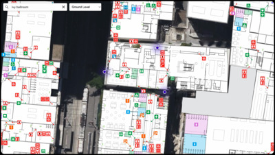
Locatrix’s plans are created and managed through PlanStudio, which turns building information into geospatially referenced indoor plans. Depending on the information captured, plans can show doors, corridors, fire equipment and hazardous materials. ESP makes that information available through agencies’ mapping environments.
The plans aren’t a live view of a building. Their usefulness depends on the source information being checked and updated as the site changes. The building owner’s compliance review process is therefore part of keeping the information useful.
What plans can add on scene
Fire and Rescue NSW’s guidance describes emergency services information packages and tactical fire plans as sources of building or site information to help firefighters develop strategies and tactics. A plan can help crews orient themselves and identify access points, internal layouts and relevant safety information
For Jackson, responder feedback reinforces the importance of making that information available through agencies’ existing systems, so crews can find it in the course of their work.
“The feedback we hear is that having the information in the systems responders already use makes it easier to find and apply. It gives crews more context about the building as they assess the incident.”
An indoor plan cannot predict how an incident will unfold or replace on-scene assessment. It can give crews a useful reference point: what the building looks like on the plan, and what they find when they arrive.
Top 5 tips for fleet and safety teams this National Safe Work Month
Zetifi has developed a list of five tips to help fleet and safety managers take stock of their...
Regional council transforms remote ops with fleet tech
MacDonnell Regional Council has transformed its remote operations to deliver safer, smarter...
Beating the jammers: Australian tech gives warfighters precision in GPS blackouts
Advanced Navigation's inertial-centric intelligence has succeeded in achieving navigation in...